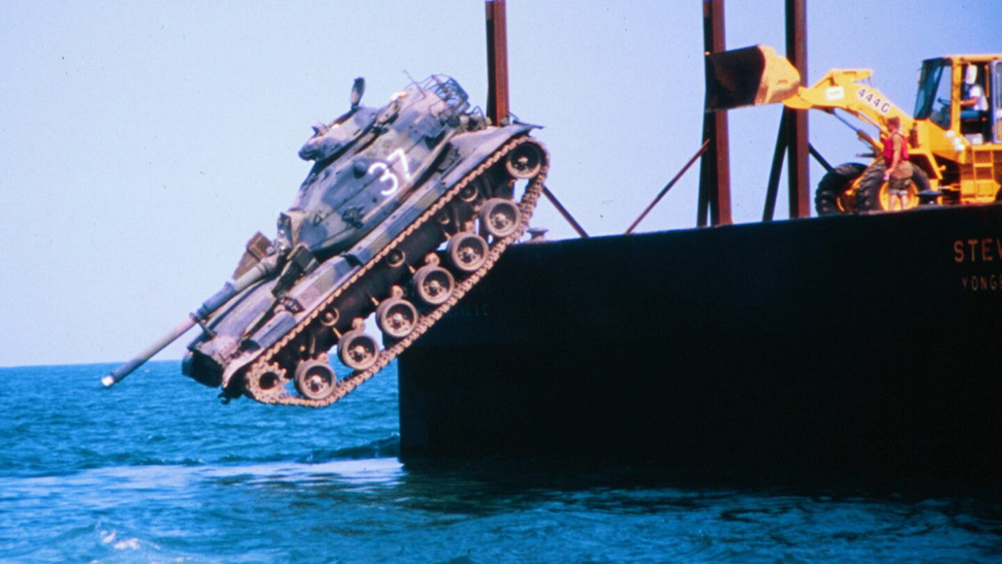
There is a lot of junk piled in the ocean off of Georgia’s coast, including battle tanks, World War II cargo ships and New York City subway cars.
These aren’t gigantic pieces of litter. They’ve been put there on purpose over the past 50 years to host more habitat for marine creatures and create more good fishing spots for anglers.
Since the program began, though, mapping tools have improved, and Georgia’s dynamic coastline and weather have shifted things around. So recently, Georgia scientists set out to create a better map of the state’s artificial reefs.
Underwater ‘oases’
“Most of the continental shelf here in Georgia is just a vast sandy wasteland,” said Clark Alexander, a coastal geologist and director of UGA’s Skidaway Institute of Oceanography. “By and large, you might think about it as a vast sandy desert.”
He said in those sandy underwater stretches you might see fish and crustaceans here and there. But reefs are where the real biodiversity is happening.
Georgia’s reefs, most notably Gray’s Reef National Marine Sanctuary, near Sapelo Island, are rocky outcrops in the sand — places where coral and sponges can find a hard surface to latch on to, which then attracts crustaceans and all kinds of fish all the way up the food chain.
“Oases in the middle of the desert,” Alexander called them.
In the 1970s, Georgia started creating more of those oases by dumping stuff in the ocean.
“What we call materials of opportunity,” said marine biologist Cameron Brinton with the Georgia Department of Natural Resources. “They’re things that are donated to us or provided at a very low cost to us.”
He said the objects they use to make reefs have to be big and heavy enough to stay on the bottom, and DNR has to be able to get them clean enough to not pollute the environment.
Once they’re there, though, it doesn’t take long for marine life to start populating them.
“Corals and sponges all have larval stages that are floating free in the water. And so they’re just drifting around and looking for a suitable location and we’re providing that location,” Brinton said.
So the artificial reefs begin with unnatural material, but what grows on and around them is natural, and comparable to a real, rocky reef.
“You can’t really see any difference between it and a natural reef except for maybe the outline of the shape,” Brinton said. “You might be able to tell, ‘Hey, that was a subway car that all these corals and sponges have grown on, or that was a tank.’”
Popular sportfish like grouper, snapper and sea bass use Georgia’s artificial reefs, as do large fish that might stop by for a bite, such as amberjack and sailfish, Hinton said. Divers also visit the artificial reefs — to see the wildlife and to spearfish.
Mapping the reefs
A whole array of things have been used for the reefs over the years. In addition to the military barges and New York subway cars, there are pieces of old bridges, metal chicken transport cages, culverts — which are popular because fish can shelter inside of them — concrete power poles and the rudder and propellor from the Golden Ray, the cargo ship that capsized near Brunswick a few years ago.
“My personal favorite are battle tanks that were donated by the Army,” Alexander said.
But after 50 years it wasn’t clear exactly where all this stuff was.
So the Skidaway Institute worked with the Georgia Department of Natural Resources to use side-scan sonar to map it all.
“We also wanted to measure the depth of water over each of these features to assure that there was adequate water depth for the large container ships and things like that, that move along the coast,” Alexander said.
The map gives divers and anglers more specific locations to plug into their GPS.
“In general, everything was where it should be,” Alexander said.
Strong storms had caused some things to shift around, and Alexander says the project opened up more questions for him about why Georgia’s ocean floor looks the way it does.
“There’s still more to be learned,” he said.
This stage of the project is done for now, but there are more artificial reefs further offshore that the state and Skidaway are hoping to map eventually.