Some in the metro area actually saw snow at their homes this week; others got not much more than cold rain and a bit of ice. Why’s it so tough for forecasters to figure out which way a snow day is going to go in Atlanta?
“It’s incredibly hard,” said meteorologist with the National Weather Service Brian Lynn. He says we should blame the location. “We’re always on the edge of a temperature structure that allows for snow versus rain or snow versus sleet versus freezing rain.”
Lynn said the city is in an inconvenient sweet spot where the temperature hovers around freezing.
“Very often the coldest air is across the northern counties, and the City of Atlanta can be either/or.”
Or, in the case of the storm earlier this week, it’s both: People north of the perimeter got snow, and people in-town didn’t.
“The rain-snow line is always very difficult to forecast,” said Marshall Shepherd, director of UGA’s atmospheric sciences program.
“To the person sitting perhaps in Covington expecting one inch of snow, and they got all rain, they think this was a forecast bust,” but it wasn’t, Shepherd said. Sure, the storm shifted north, but the forecast was pretty close, as he points out in the maps below.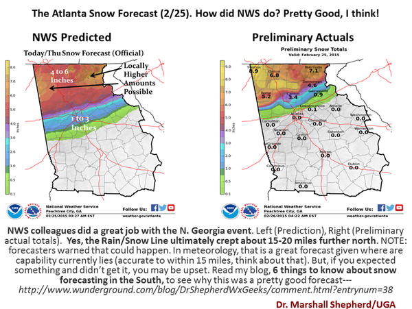
“These days, people want pinpoint forecasts for their backyards,” said Shepherd.
They also want their politicians to make the right call when it comes to closing schools and businesses, and if officials are erring on the side of caution after last year’s meltdown, Shepherd says that’s OK.
9(MDAxODM0MDY4MDEyMTY4NDA3MzI3YjkzMw004))