Hurricane Dorian Churns Toward Florida Coast, Expected To Bring 125 MPH Winds
NOAA/ NWS
Updated at 10:30 a.m. ET
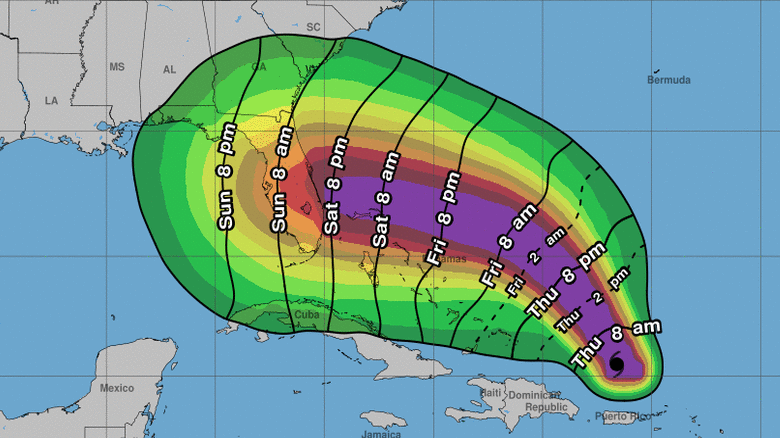
Hurricane Dorian is predicted to hit Florida and the northern Bahamas this weekend as a dangerous Category 3 storm, bringing intense rains and sustained winds of 125 mph, the National Hurricane Center says.
With favorable conditions and very warm waters ahead, Dorian is expected to have a fearsome growth spurt in the next 48 hours. As the NHC says, “all of the intensity models forecast Dorian to begin strengthening again soon, and rapid intensification could occur.”
Florida Gov. Ron DeSantis has declared a state of emergency for 26 counties in the current path of the hurricane, citing forecasters’ dire predictions of high winds and the chance for a damaging storm surge and flooding.
As of Thursday morning, Dorian was expected to make landfall as a major hurricane early Monday. But its strong winds will arrive hours earlier — and many parts of Florida could feel the storm’s effects, says NHC Director Ken Graham.
“Please don’t think this is just coastal,” Graham says in a video update Thursday morning. “This is over the whole state.”
Dorian also is expected to maintain its hurricane status as it moves inland — a process Graham said would be slow and dangerous and could produce “high impacts” through persistent wind and rain.
Pointing to an “M” on the forecast map that denotes Dorian’s approach as a major hurricane and then to an “H” near the center of Florida, Graham added, “The distance here is about 24 hours.”
Dorian is poised to be the most powerful hurricane to strike Florida’s east coast in decades. Last year, Hurricane Michael became the first Category 5 hurricane to hit the contiguous United States since Andrew in 1992. But Michael made landfall on the Gulf side of Florida, at Mexico Beach.
In 2017, Hurricane Irma made landfall as a Category 4 storm in the Florida Keys, before hitting the state a second time on its Gulf Coast.
Dorian has now left the Caribbean Sea and is over the open Atlantic Ocean, about 150 miles north-northwest of San Juan, Puerto Rico. It has 85 mph winds and is moving northwest at 13 mph, the National Hurricane Center says in its 5 a.m. ET update.
Dorian drenched parts of Puerto Rico, St. Thomas and other islands on Wednesday. The storm became a hurricane as it approached those land masses, with sustained winds of 75 to 80 mph. Despite raising alarms in a string of Caribbean islands, there have been no reports that Dorian caused extensive damage — a relief for areas that are still working to recover from the ravages of Hurricane Maria and Hurricane Irma in 2017.
“Thankfully, there were no reports of major damage here,” NPR’s Adrián Florido reports from San Juan. He adds that in the U.S. Virgin Islands, “there were widespread power outages” in both St. Thomas and St. Croix, along with some flooding.
In Puerto Rico, the newspaper El Nuevo Día says that compared with Maria and Irma, Dorian served as “a great drill” to put the government’s response system to a test.
Now it’s Florida’s turn to prepare, as a major hurricane heads toward its central east coast. The first tropical-storm-force winds could hit the state as early as Saturday night.
Both DeSantis and Florida’s Sen. Rick Scott said that they spoke to President Trump on Wednesday night and that he had assured them the federal government is ready to help Florida.
Pete Gaynor, acting administrator of the Federal Emergency Management Agency, says the National Response Coordination Center is now at Level 1, its highest level, because of the storm. Listing FEMA’s priorities in a tweet, Gaynor says it will help in “re-establishing communications & power after the storm & coordinating federal resources to support local government needs.”
Warning against taking the forecast’s five-day cone too literally — and assuming landfall will occur precisely where the current path hits the coast — the NHC’s Graham said, “Two-thirds of the time, based on our average error over the last five years, you could see the center of this system anywhere inside this cone.”
That means that everyone from southern Georgia all the way down to the Florida Keys “really has to pay attention to this system,” Graham said.
For much of the next 48 hours, Dorian will likely be on a fairly northwestern track. It’s then predicted to make a left turn to the west-northwest. But the timing and angle of that shift remains uncertain, meaning any landfall predictions are very likely to change. Forecast models are predicting a number of potential paths into Florida’s coast, ranging from near the Georgia border to South Florida. The current projection is based on a consensus of those predictions.
“We don’t want anybody focusing on exactly where the center would come ashore,” says NHC spokesman Dennis Feltgen, “because hurricanes, as we know, are not a dot on a map. Their impacts are over a wide area.”
With the storm at sea, no coastal watches or warnings are currently in effect for Dorian. But forecasters say it could skim the northwestern Bahamas on its way to the U.S. mainland.
The Bahamas Department of Meteorology is monitoring the hurricane, but it says that because the storm’s track has stayed to the east, the island chain might suffer only a glancing blow from Dorian.
While Dorian caused some flooding and isolated damage in the Caribbean, there are now sighs of relief, as leaders give thanks and schools and businesses prepare to open.
In the British Virgin Islands, the Terrance B. Lettsome International Airport on Beef Island reopened early Thursday.
Giving a summary of the hurricane’s effects late Wednesday night, BVI Premier Andrew Fahie said, “Thanks be to God that we have had no reports of loss of lives, serious injuries, major property damage, crimes or problems in relation to businesses being compromised. ”
9(MDAxODM0MDY4MDEyMTY4NDA3MzI3YjkzMw004))
Related


Top Stories