Atlanta’s Sprawl Tops the List for Major U.S. Cities

Atlanta is the ninth largest metropolitan area in the country by population, but it tops the list for sprawl.
“It means that jobs and housing are spread out and not pulled together,” says Ilana Preuss, the vice president and chief of staff of Smart Growth America.
The “Measuring Sprawl 2014” report is based on four major factors: development densities, land use mix, activity centering and street accessibility.
Smart Growth America promotes anti-sprawl actions, like improving mass transit and developing pedestrian-friendly areas.
The organization says severe sprawl can lead to major problems for residents, partly because they are forced to spend more time inside their vehicles.
An audio version of this story.
“Very likely the population is having shorter, less healthy, less safe lives as compared to other metropolitan areas who are more connected and more compact,” says Preuss.
The Atlanta Regional Commission is taking this report in stride, partly because the findings are based on data over the past 50 years.
Officials say cities in metro Atlanta have made changes more recently aimed toward improving quality of life for residents.
“We’ve really seen places like the city of Atlanta, Decatur, Woodstock, Suwanee….we’ve seen a lot of communities become more walkable and more mixed-use,” says Dan Reuter, with the ARC.
More steps in that direction are expected over the next few years as well.
“I think metro Atlanta is a leader and I think we should be proud of the things that we’ve done in the last 10 to 20 years,” says Reuter.
A Smart Growth America report from last year showed metro Atlanta’s push toward creating more dense, pedestrian-friendly areas more than tripled between the 1990’s and 2009.
The Smart Growth America report used a number of factors to generate scores for comparing metropolitan areas around the country. These included land use mix, census tract density, percentage of people living in low vs. high density census tracts, employment density, street accessibility, and a number of additional factors.
Another way to understand the extent of Atlanta’s sprawl is to consider it visually. Below are a few examples from other sources that illustrate Atlanta’s sprawling layout.
Atlanta and Hong Kong: Same Population, Vastly Different Area
LSECities, an international research center located at the London School of Economics and Political Science, researches the geography of cities around the world. In one particular study, “Measuring the Human Urban Footprint,” they compare the size and density of various cities around the world with a series of maps. They explain their map design as follows:
To get a sense of the spatial dynamics of these city regions, we mapped 12 cases at the same scale with core built-up areas in black and peripheral areas in grey. By comparing the footprint of the world’s largest urban conurbation in Tokyo with Atlanta, our sample’s most land-hungry city region, we see that roughly the same amount of land is occupied by 42 million as by 7.5 million people.
In other words, Atlanta and Tokyo occupy the same amount of land, but the Tokyo region has 42 million people while the Atlanta region has only 7.5 million people taking up that space.
Similarly, Atlanta and Hong Kong have roughly the same overall population (between 7.0 and 7.5 million people), but Atlanta covers 25 times the land area of Hong Kong.
As you look at these maps, keep in mind that (a) these are drawn to the same scale and (b) Hong Kong has the same number of people as Atlanta.


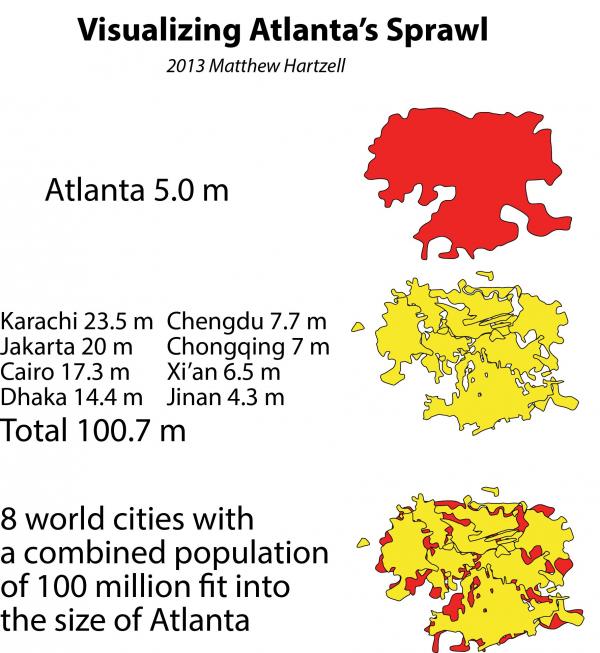
Eight Cities With Combined Population of 100 Million Can Fit Into Atlanta’s Footprint
For a different comparison, consider the following infographic by Matthew Hartzell. Using representations of major cities drawn to the same scale, he demonstrates that he can fit 100 million people into the same area Atlanta uses to fit its population (population figures vary somewhat from the previous set of maps). If you follow the link above, you can see how he does this, but below is the final result:
Seeing Atlanta From Space
Finally, Atlanta’s sprawl is perhaps most visible at night. This amazing photo of Atlanta at night was taken (and tweeted) by Canadian astronaut Chris Hadfield from the International Space Station last year. You can see Hartsfield-Jackson airport in the lower left of the image. The distance from downtown to the airport provides a visual scale to just how far Atlanta reaches.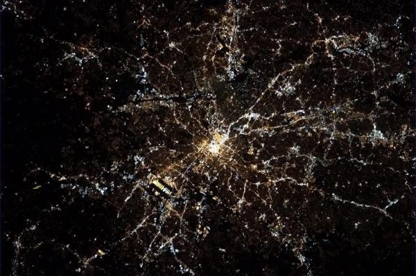
9(MDAxODM0MDY4MDEyMTY4NDA3MzI3YjkzMw004))


Top Stories